


Grady, McClain & Pottawatomie (South) Counties PUMA, Oklahoma
About
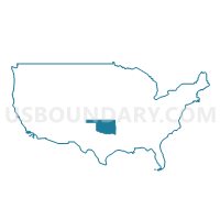
Outline
+Counties+PUMA%2c+Oklahoma_A280.png)
Summary
| Unique Area Identifier | 193793 |
| Name | Grady, McClain & Pottawatomie (South) Counties PUMA |
| State | Oklahoma |
| Area (square miles) | 2,190.31 |
| Land Area (square miles) | 2,173.22 |
| Water Area (square miles) | 17.09 |
| % of Land Area | 99.22 |
| % of Water Area | 0.78 |
| Latitude of the Internal Point | 35.03453060 |
| Longtitude of the Internal Point | -97.55888250 |
Maps
+Counties+PUMA in Oklahoma.png)
Graphs
Select a template below for downloading or customizing gragh for Grady, McClain & Pottawatomie (South) Counties PUMA, Oklahoma
+Counties+PUMA%2c+Oklahoma_T0.png)
+Counties+PUMA%2c+Oklahoma_T1.png)
+Counties+PUMA%2c+Oklahoma_T2.png)
+Counties+PUMA%2c+Oklahoma_T3.png)
+Counties+PUMA%2c+Oklahoma_T4.png)
+Counties+PUMA%2c+Oklahoma_T5.png)
+Counties+PUMA%2c+Oklahoma_T6.png)
+Counties+PUMA%2c+Oklahoma_T7.png)
+Counties+PUMA%2c+Oklahoma.png)
Neighbors
Neighoring Public Use Microdata Area (by Name) Neighboring Public Use Microdata Area on the Map
- Canadian County--Oklahoma City (West) PUMA, OK
- Carter, Garvin, Murray, Love & Pontotoc (West) Counties PUMA, OK
- Cleveland County--Norman, Oklahoma City (South) & Moore Cities PUMA, OK
- Payne, Seminole, Creek (Southwest), Hughes & Okfuskee Counties--Stillwater City PUMA, OK
- Pottawatomie (North), Logan & Lincoln Counties--Shawnee City PUMA, OK
- Stephens, Caddo, Comanche (North), Tillman, Jefferson & Cotton Counties PUMA, OK
Top 10 Neighboring County (by Population) Neighboring County on the Map
- Cleveland County, OK (255,755)
- Comanche County, OK (124,098)
- Canadian County, OK (115,541)
- Pottawatomie County, OK (69,442)
- Grady County, OK (52,431)
- Stephens County, OK (45,048)
- Pontotoc County, OK (37,492)
- McClain County, OK (34,506)
- Caddo County, OK (29,600)
- Garvin County, OK (27,576)
Top 10 Neighboring County Subdivision (by Population) Neighboring County Subdivision on the Map
- North Cleveland CCD, Cleveland County, OK (121,027)
- Norman CCD, Cleveland County, OK (102,464)
- East Canadian CCD, Canadian County, OK (86,541)
- Shawnee CCD, Pottawatomie County, OK (64,590)
- El Reno CCD, Canadian County, OK (26,531)
- East Cleveland CCD, Cleveland County, OK (22,860)
- Chickasha CCD, Grady County, OK (20,375)
- Purcell CCD, McClain County, OK (17,169)
- Newcastle-Blanchard CCD, McClain County, OK (15,994)
- Tuttle CCD, Grady County, OK (15,076)
Top 10 Neighboring Place (by Population) Neighboring Place on the Map
- Oklahoma City city, OK (579,999)
- Norman city, OK (110,925)
- Shawnee city, OK (29,857)
- Chickasha city, OK (16,036)
- Newcastle city, OK (7,685)
- Blanchard city, OK (7,670)
- Noble city, OK (6,481)
- Tecumseh city, OK (6,457)
- Tuttle city, OK (6,019)
- Purcell city, OK (5,884)
Top 10 Neighboring Elementary School District (by Population) Neighboring Elementary School District on the Map
- South Rock Creek Public School, OK (1,880)
- Middleberg Public School, OK (1,532)
- Pioneer Public School, OK (1,287)
- Friend Public School, OK (1,125)
- Byars Public School, OK (558)
Top 10 Neighboring Unified School District (by Population) Neighboring Unified School District on the Map
- Moore Public Schools, OK (125,679)
- Norman Public Schools, OK (107,263)
- Mustang Public Schools, OK (46,023)
- Shawnee Public Schools, OK (26,391)
- Chickasha Public Schools, OK (16,511)
- Noble Public Schools, OK (15,793)
- Tecumseh Public Schools, OK (9,799)
- Blanchard Public Schools, OK (8,289)
- Lexington Public Schools, OK (8,240)
- Tuttle Public Schools, OK (8,069)
Top 10 Neighboring State Legislative District Lower Chamber (by Population) Neighboring State Legislative District Lower Chamber on the Map
- State House District 91, OK (44,349)
- State House District 46, OK (44,285)
- State House District 47, OK (41,973)
- State House District 42, OK (37,553)
- State House District 51, OK (37,430)
- State House District 27, OK (36,934)
- State House District 22, OK (36,386)
- State House District 25, OK (36,224)
- State House District 50, OK (35,868)
- State House District 28, OK (35,663)
Top 10 Neighboring State Legislative District Upper Chamber (by Population) Neighboring State Legislative District Upper Chamber on the Map
- State Senate District 24, OK (98,936)
- State Senate District 15, OK (87,049)
- State Senate District 45, OK (85,350)
- State Senate District 23, OK (80,676)
- State Senate District 16, OK (78,677)
- State Senate District 31, OK (78,520)
- State Senate District 28, OK (76,209)
- State Senate District 17, OK (74,685)
- State Senate District 13, OK (73,191)
- State Senate District 26, OK (69,504)
Top 10 Neighboring 111th Congressional District (by Population) Neighboring 111th Congressional District on the Map
- Congressional District 4, OK (785,424)
- Congressional District 5, OK (749,336)
- Congressional District 3, OK (732,394)
Top 10 Neighboring Census Tract (by Population) Neighboring Census Tract on the Map
- Census Tract 9.03, Grady County, OK (9,327)
- Census Tract 4001.02, McClain County, OK (9,323)
- Census Tract 4002.02, McClain County, OK (7,996)
- Census Tract 5011.02, Pottawatomie County, OK (7,907)
- Census Tract 7, Grady County, OK (7,465)
- Census Tract 2024.05, Cleveland County, OK (7,006)
- Census Tract 8, Grady County, OK (6,981)
- Census Tract 21, Comanche County, OK (6,966)
- Census Tract 5009, Pottawatomie County, OK (6,881)
- Census Tract 2025, Cleveland County, OK (6,720)
Top 10 Neighboring 5-Digit ZIP Code Tabulation Area (by Population) Neighboring 5-Digit ZIP Code Tabulation Area on the Map
- 73072, OK (42,797)
- 73170, OK (35,343)
- 74820, OK (30,802)
- 74801, OK (21,657)
- 73064, OK (20,611)
- 73018, OK (19,936)
- 73010, OK (17,563)
- 74868, OK (13,152)
- 74873, OK (11,821)
- 73068, OK (11,707)